This post has been updated to include the latest 2025 Maps showing the State Responsibility Areas (SRA) and the Local Responsibility Areas (LRA) for Novato. Cal Fire’s predictions didn’t foresee the Altadena inferno. Now it’s changing its fire-hazard maps.
“Gov. Gavin Newsom’s office said the maps, when completed, would add at least 1.4 million acres across the state into zones where many heightened fire safety regulations are required, more than doubling the land under local fire departments’ purviews with these highest severity designations. More than 360,000 of those acres are in the coastal Northern California region.” Ref: Cal Fire releases new hazard maps for the Bay Area and wine country
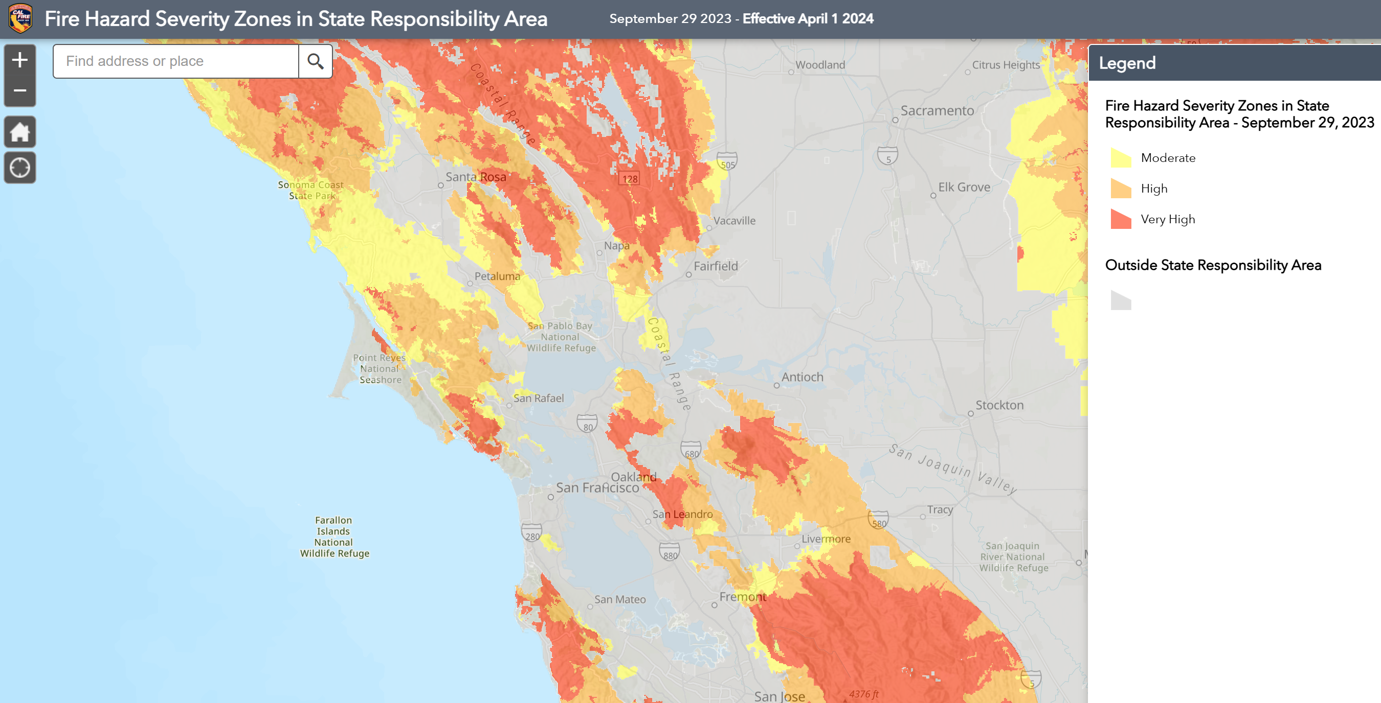
State Responsibility Areas (SRA) Map: Fire Hazard Severity Zones in State Responsibility Area – this links to a map viewer app (see instructions below) and note that ‘grey’ areas are Local Responsibility Areas
Novato Local Responsibility Areas (LRA) Map: Fire Hazard Severity Zones in Local Responsibility Area – City of Novato – this is a simple PDF file but also see this Novato Fire Protection District page for detailed background information on the maps and links to the LRA Maps for other cities.

Wildfire zone risk in California has become a huge concern for all of us, whether we are homeowners, Association members, or Insurance companies. For safety and insurance reasons it’s important to know your proximity to the higher risk wildfire zones and how the new 2025 maps may have changed your risk assessment from the previous maps.
This post answers 3 key questions:
- How can you see and understand your wildfire risk level?
- What are the top tips on creating defensible space?
- What does the future hold for Single Family Owners and Association Homeowners in Wildfire Areas?
1. Understand Your Wildfire Risk Level – See Your Proximity to Wildfire Zones
One way is to look at your proximity to a wildfire zone in publicly available data. The California Department of Forestry and Fire Protection’s Fire and Resource Assessment Program (FRAP) assesses the amount and extent of California’s forests and rangelands, analyzes their conditions and identifies alternative management and policy guidelines. Click on the map links above.
Instructions to Use the SRA Map Viewer
- Click on one of the above Link to view the SRA Fire Hazard Severity Zones map
- On the new map use the ‘Find Address or Place’ search box on the upper left side of the page
- Enter your property address, full address, city, state, and zip code, for example, 455 10th St. Davis, CA 95121
- Zoom in or out (using the + and – icons) to see the area you are interested in including the nearest shaded Fire Hazard Zones
- The legend/key shows the risks by color. Red means Very High Risk. Orange means High Risk. Yellow means Moderate Risk. Areas outside these wildfire zones aren’t colored. Grey means it’s a Local Responsibility Area (LRA) – for the Novato Area click on LRA map link above.
2. What Are the Top Tips on Creating Defensible Space?
One of the best guides we’ve seen is this one, available for download here.
3. What Does the Future Hold for Single Family Owners and Association Homeowners in or near a Wildfire Zone?
Will insurance rates get worse, better, or stay the same? As well as the maps above, insurance companies procure regularly updated fire risk maps from specialist suppliers. Those maps aren’t publicly available. Different insurance companies evaluate their individual risks, and competition between them ensures the wildfire risk is priced appropriately. Sometimes, a non-renewal by one company can be acceptable to another company! For example, I have found Travelers says one area is high wildfire risk, and Farmers says it is moderate wildfire risk. The drought of recent years has increased wildfire risks, but, on the other hand, the systems that have caused wildfires are being hardened and vegetation better managed.
Call me if you’d like to discuss your wildfire risk level and coverage. Also see this blog post: Home Reconstruction Cost: How Much Coverage Do You Need?